




XGRIDS Lixel L3
Accuracy meets photorealism
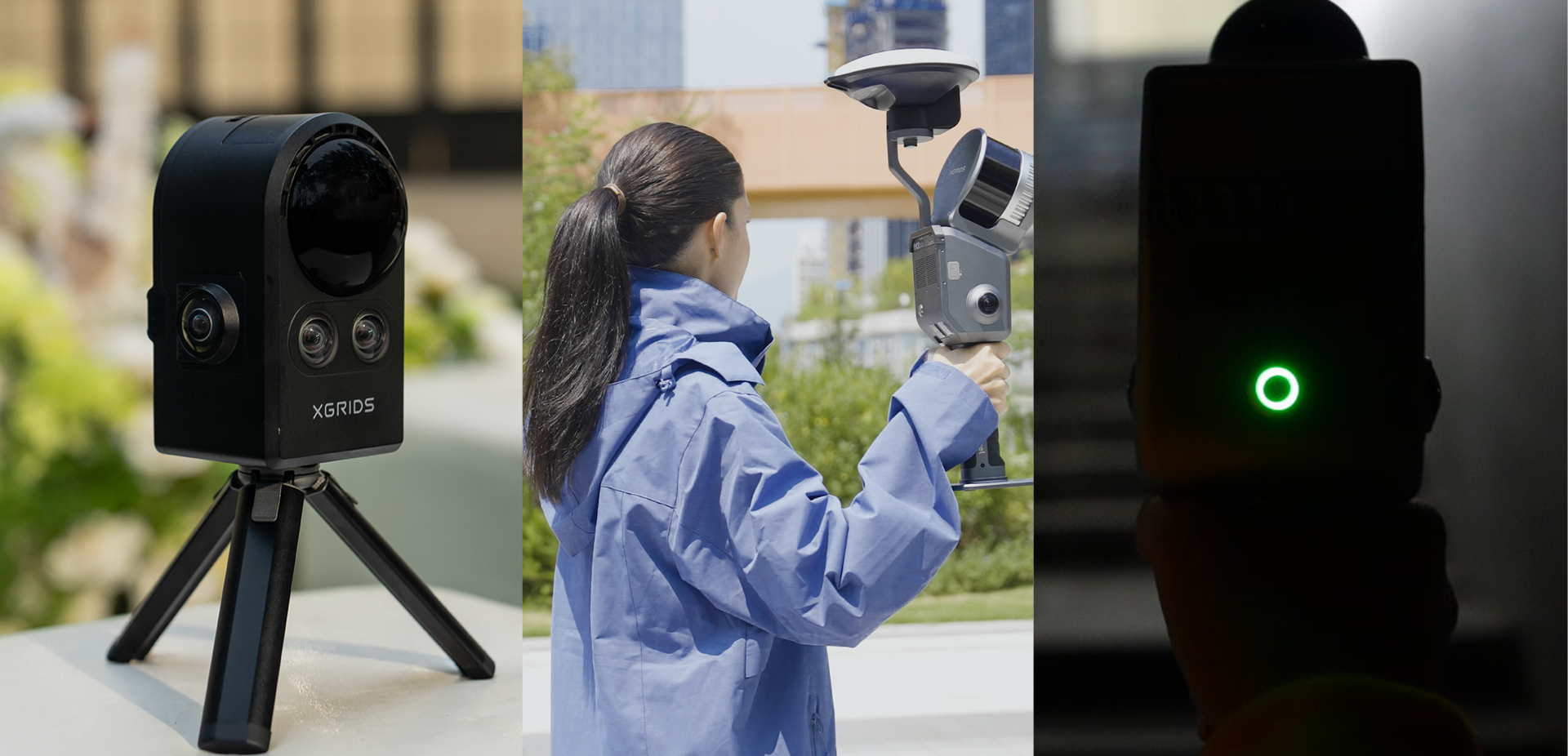
The Lixel L3 combines a validated relative accuracy of 5mm, 4K HDR true color imagery, and integrated RTK into a mobile spatial scanner that produces 3DGS point clouds, meshes, and LCC from a single capture.
5mm precision, customers can trust and understand
Lixel L3 offers:
- 5 mm of post-processed relative precision
- 2 cm of absolute precision
- 2.5 cm of real-time absolute precision
- 0.005° leveling with RTK fusion
The 5 mm figure is supported by a documented test method, measurement data, and clearly established test conditions, which helps partners explain not only the number, but also where it applies.

Image-grade true color vision
The Lixel L3 combines a 1/1.3-inch sensor, a 3 × 50 MP camera array, and 4K HDR imaging.
The result is a structurally accurate point cloud with more natural colors, materials, and light and shadow details. Objects are easier to identify, measurements and modeling are more straightforward, and results are easier to explain to clients.
Selected objects, such as railings, pipes, and nameplates, can also be locally enhanced without increasing the processing time and size of the entire data set.

Most Useful Results Directly From the Field
Integrated RTK, real-time closed-loop, leveling optimization, and AI-powered filtering work together during capture.
-
Reduce drift and stratification in large areas
-
Maintain stability in repetitive or featureless environments
-
Remove moving people, vehicles, and noise
-
Convert WGS 84 and CGCS2000 coordinates in real time
-
Produce true-color point clouds that can move more quickly into measurement and drawing
-
The real-time point cloud is designed to be a usable project output, not just a coverage preview.
One scan, three spatial outputs
One visit. One dataset. Multiple professional deliverables.
Full-color point cloud
Precise geometry and natural site colors for measurements, CAD design, BIM, and engineering work.
Mesh
Detailed surfaces, textures, and structural lines for modeling and visualization.
3D Gaussian Splatting
A photorealistic and immersive space scene for digital twins, exploration of remote locations, visualization, virtual production, and simulation.
Smoother Field Operation
The built-in 4.3-inch, 1000-nit display shows the point cloud, trajectory, and coverage without the need for a connected phone.
The support cradle bears the weight of the device, while the survey pole’s direct connection and the control point tip facilitate control point collection and elevated capture.
Flexible Processing
Local Reconstruction LixelStudio
Multiple scan segments can be merged by region selection matching without control points.
Privacy-Ready Delivery
Automatic detection and blurring of faces and license plates reduces the need for frame-by-frame masking before sharing data from public spaces.

Open data for existing workflows
For customers who develop their own workflows:
- LixelStudio provides access to Creator Data, including perspective images and COLMAP datasets.
- LCC provides access to original image data and intermediate 3DGS data.
- SDKs and plugins support further integration and application development.
Point clouds support CAD and Scan-to-BIM workflows. 3DGS can connect with Unreal Engine for location scouting, pre-visualization, and virtual production, and with NVIDIA Isaac Sim for simulation.
Specifications
| Category | Specification | Lixel L3 |
|---|---|---|
| Hardware | Dimensions | 206 x 107 x 329 mm |
| Energy consumption | < 30 W | |
| Weight | Approx. 2.5 kg | |
| Data interface | USB 3.1 Gen 2 | |
| Internal storage 1 TB UFS |
||
| RTK Module | Integrated | |
| Wi-Fi | 802.11 a/b/g/n/ac/ax; 2,400–2,4835 GHz; 5,15–5,850 GHz | |
| Bluetooth | v2.1+EDR / 3.0+HS / 4.2 / 5.0 / 5.2; 2,4–2,4835 GHz | |
| Casing | Aluminum alloy | |
| Operating environment | Operating temperature | -20 °C to 50 °C |
| IP54 | ||
| Battery | Battery voltage | 14,4 V |
| Battery capacity | 3.350 mAh | |
| Total operating time | ||
| Screen | Size | 4,3″ TFT |
| Brightness | Up to 1,000 nits | |
| Resolution | 480 × 800 | |
| Survey-grade GNSS module | BDS B1I, B3I, B1C, B2a, B2b; GPS L1C/A, L1C, L2C, L2P(Y), L5; GLONASS G1, G2, G3; Galileo E1, E5a, E5b, E6; QZSS L1C/A, L1C, L2C, L5, L6; IRNSS L5; SBAS L1C/A | |
| Accuracy | Horizontal: 0.8 cm + 1 ppm; Vertical: 1.5 cm + 1 ppm | |
| Maximum Gain / Coverage | 4,0 dBi / 360° | |
| Impedance / Polarization | 50 Ω / Right-hand circular polarization (RHCP) | |
| Axial ratio / Output VSWR | ≤ 3 dB / ≤ 2,0 | |
| LiDAR Module | Laser Class | Class 1 (905 nm) |
| Range | 0,7–120 m | |
| Field of view | ≈360° × 270° | |
| Point rate | 16 channels: 320,000 pts/s; 32 channels: 640,000 pts/s | |
| LiDAR Channels | 16 channels / 32 channels | |
| Vision module | ||
| Front camera FOV | 100° × 75° | |
| Panoramic cameras | 2 | |
| Field of view of panoramic cameras | 200° × 200° | |
| Camera resolution | 4096 × 3072 | |
| Size of the CMOS sensor | 1/1,3″ | |
| Shutter | Rolling shutter | |
| HDR | DCG HDR | |
| Precision | Post-processed relative precision | 5 mm, tested in a specific environment of 500 m² |
| Post-processed point cloud thickness | ≤ 5 mm | |
| Vertical Absolute Accuracy (RMSE) | ||
| Absolute Horizontal Accuracy (RMSE) | 2 cm | |
| Repeatability | 2 cm | |
| Real-time relative precision | 1 cm | |
| Real-time horizontal absolute precision (RMSE) | 2,5 cm | |
| Real-time absolute vertical precision | 2,5 cm | |
| Leveling with RTK Fusion | 0,005° | |
| Leveling without RTK Fusion | 0,02° | |
| Real-time processing | Dynamic object removal using AI | Compatible |
| AI Noise Filtering | Compatible | |
| True color point cloud | Compatible | |
| Vision-assisted positioning | Compatible | |
| On-device | On-screen model preview and measurement | Compatible |
| Post-processing | POI point cloud enhancement | Compatible |
| Fusion of Control Point Cloud Maps | ICP, GCP, Scan Overlay | |
| Blurring of faces and license plates | Compatible | |
| Not specified | ||
| Output formats | Point cloud | .las, .rcp, .e57, .ply, .ilas |
| Images | .jpg | |
| Mesh | .osgb, .obj | |
| 3DGS | .lcc2, .lcc, .ply | |
| Others | 3D Tiles (.3tz), .usd | |
| Base Mount | Standard | |
| Standard | ||
| Standard | ||
| Support Rig | Optional | |
| Compatible with standard RTK surveying poles | ||
| Drone Mount | Coming Soon | |
| Coming Soon | ||
| Coming Soon |